Navigation
User login

Contradictory Locations
Contradictory Locations
Contradictory Locations.The Republic sank 8:10 p.m., Sunday January 24th, 1909. Her plotted positions, taken at the time of her sinking by vessels immediately involved with rescue efforts, were as follows:
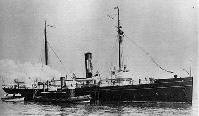
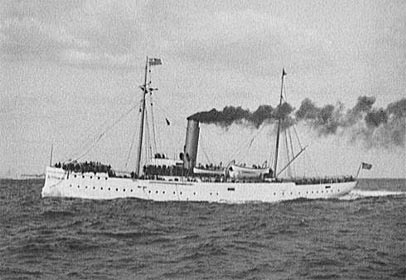
8 p.m. to Mid.: - At 8:10 S.S. 'Republic' indicated that she was sinking and she soon went down leaving her captain and second officer in the water. Hauled in hawser and sounded getting 40 fms. Stood by, playing searchlight on place where wreck disappeared as did also 'Gresham' and tug. Captain and second officer of 'Republic' picked up by 'Gresham's' lifeboat, and taken to that vessel. Made signal offering to take shipwrecked crew on board and transport them to New York. 'Gresham' asked that transfer be deferred until morning and that 'Seneca' meet her near Gay Head for the purpose. 9:24 steamed ahead, over log (13.3), course N.W. 1/8W.(mag) for No Man's Land, keeping in touch with 'Gresham'. [signed] M.J. Ryan 3rd Lieut. Log of the U.S. Revenue Cutter REPORT OF ASSISTANCE RENDERED By the U. S. Revenue Cutter SENECA Date of Service Rendered, Sunday, January 24th, 1909.
[Dated February 19, 1909] Sir: Referring to my report of January 26, 1909, in regard to the assistance rendered the Steamship REPUBLIC, I have the honor to say that the location where we found the vessel, and also the place where she sank, as stated in said report, and given on the small chart accompanying the same, are slightly in error. The vessel was found 12.5 miles S. 9° W. (mag.) from Nantucket South Shoals Lightvessel and she sank in latitude 40°25'30", N., longitude 69°40', W., 11.7 miles S. 23° W. (mag) from the lightvessel above-named - in 40 fathoms of water, as nearly as we can estimate. The errors in the position first reported were due to a mistake in giving in the distances as indicated by the patent log. I request that this correction be noted on the report, and that the inclosed small chart be substituted for the one filed with the report. Respectfully, Reference as titled.
New York Sun, January 26, 1909, 4:1. 8 P. M. - Mid.:- P. W. Lauriat, 2nd Lieut. Transcript of the log of the U.S.R.C. Although the report of the GRESHAM and the corrected report of the SENECA differ by 8 nautical miles as to the actual sinking position of the REPUBLIC, both reports agree that she sank in forty fathoms of water. Both reported positions lie on the forty fathom line, and in actuality, the REPUBLIC lies on a line almost equidistant between the two positions cited, and on the forty fathom line. These Revenue Cutter reports, however, were not accessible to the public at large at that time. The one and only published contemporaneous location given by Capt. Perry (found by this researcher to date), reported in the New York Sun, above, appears to have been released by the Captain immediately upon his return to Woods Hole, possibly before he was officially "debriefed." However, the British Hydrographic Office Bulletin of 1909, the "official" authority which was available and distributed to the public at large, places the site of the REPUBLIC at latitude 40°28'40" N., longitude 69°38'40" W, in 36 fathoms of water 9 nautical miles W.S.W of the Nantucket Shoals Light Vessel and approximately 7 nautical miles distant from her actual location. This is the position used in Berman's book Encyclopedia of American Shipwrecks,1 and several other texts. A Republic officer also misplaces her true location. At 6 p.m. the U. S. revenue cutter SENECA hove in sight and came alongside the GRESHAM and we passed a hawser to her to assist the tow. Both cutters were now towing the REPUBLIC and were making about two knots. At 8:05 p.m. the prearranged signal was made from the REPUBLIC, 'I am sinking.' We immediately launched a boat from the GRESHAM and cut the towing hawser. We had no difficulty in finding the captain and second officer with the aid of the cutters' searchlights, and we brought them on board at 8:15. The GRESHAM then steered for Woods Hole, where we arrived at 5 a.m. on Monday, January 25. Here we transferred to the SENECA and proceeded to New York, where we arrived at 10 p.m. The REPUBLIC sank in 34 fathoms of water, about 10 miles South of Nantucket light vessel. ... Sea Breezes Magazine, Jan - June, 1950, Vol. IX, Because of the British Hydrographic Office's report, the cited position was incorrectly considered by most researchers as the actual REPUBLIC site. The British Hydrographic Office position would require a 132 square mile search area to locate the REPUBLIC, which would then be at the extreme perimeter of the search. Using this reported 1909 position and the technology of 1909, it would be virtually impossible to locate the REPUBLIC. Even with the best information, locating an offshore sunken vessel in 1909 was extremely difficult. Generally, salvors would trawl a cable between two search vessels; when that cable would snag on a bottom obstruction, forming a "v" between the two search vessels, a diver or an observation bell would be sent to the apex of the "v" to determine the nature of the obstruction. Inshore searches could use land bearings to lay out a search pattern, "mowing the lawn." Offshore searches had to rely upon celestial navigational aids and dead-reckoning - tools made nearly impossible to use for an accurate fix in poor-weather conditions.
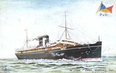
The 8,000 ton P. & O. liner RMS Egypt carried approximately $5 million in gold and silver when she was lost, also as a result of collision in fog, in 1922. The search for the SS Egypt provides some indication of the period's technological limitations.
Seventy Fathoms Deep, David Scott, Faber & Faber Limited, London, 1931, p. 127, 8. The ships of the Sorima Company spent the whole of the 1929 and 1930 seasons in searching for the wreck of the Egypt in the Bay of Biscay. The first Artiglio located it at the end of August 1930. The second Artiglio worked on the wreck for six months in 1931 and for nearly three months in 1932 before reaching the bullion. The first gold was salved on June 22, 1932. The Egypt's Gold, David Scott, Penguin Books, 1939, p. 270. Ibid., Seventy Fathoms, p. 248. Ibid., Egypt's Gold, p. 256. In reporting the Republic's position, for some reason the British Hydrographic Office did not use the positions reported by the U.S. Revenue Cutter Service vessels who actually participated in the rescue and towing, and who were on site at the time of the Republic's sinking. The "source" of the British Hydrographic Office's incorrect position, which is the very same position also cited by official US sources (the Department of the Navy, the U.S. Coast and Geodetic Survey and NOAA, infra), is unknown, unless, of course, there was no source for this incorrect position - perhaps because the public information was designed to be deliberately deceptive. Another source that was examined in an effort to pre-determine the REPUBLIC's location were the anti-submarine warfare (A.S.W.) charts produced by the U. S. Navy. During World Wars I and II, U. S. maritime forces located and plotted virtually every shipwreck and ocean bottom obstruction for use in anti-submarine warfare defense. Wrecks were routinely leveled by depth charge attack, wire dragging, or other means to preclude their use as sonar detection screens for enemy U-boats. Strategic bottom obstructions were dynamited. The REPUBLIC, a 15,000 ton, 570 foot vessel with a 70 foot beam, lying directly in the center of the outbound shipping traffic lane, from all appearances remained undisturbed during both World Wars; she does not exhibit any of the typical destruction that has befallen other wartime wrecks, nor is her position indicated on the W. W. II anti-submarine warfare charts that had been declassified and released for public consumption.
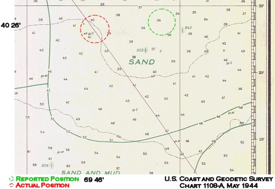
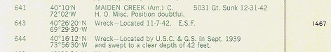
Given the publicly reported position for Republic, one would assume that Wreck 643, in 36 fathoms of water, would most likely be the Republic. We commenced our search in this area, to no avail. We then proceeded to our secondary search area, on the forty fathom line - and where no wreck is located on the official WWII charts, and located Republic's true resting place. In subsequent years, the wreck at position 643 was marked PD, for "Position Doubtful," and was eventually removed from later charts of this area. It would be virtually impossible for the Republic to go undetected from the pre-World War I time of her sinking through the entire duration of W. W. II. It was routine, however, for valuable or "sensitive" wrecks to be omitted from classified charts upon declassification. If the Republic had carried a valuable cargo of an ally (French or Russian), she would also remain undisturbed. As recently as 1962, the Department of Navy, Oceanographic Office, in its Notice to Mariners,2 placed the Republic at "approximately 40° 28' 40" N., 69° 38' 40"," or at the very same incorrect position cited by the original British Hydrographic Office report.3 And, even today,4 the U.S. Government's National Oceanographic and Atmospheric Administration continues to publish the same incorrect position. But, shortly after Captain Bayerle filed his claim on the wreck and made known the Republic's true location, at least the fishing charts of the area (commonly available at most sport fishing supply stores!) changed; they now specify Captain Bayerle's position as the actual location of the Republic.5 |
|||||||||||||||
FOOTNOTES1Mariners Press, Boston, Ma, 1972, page 140. |
|||||||||||||||